Geolocate

Kingsmere topographic map

Click on the map to display elevation.

About this map

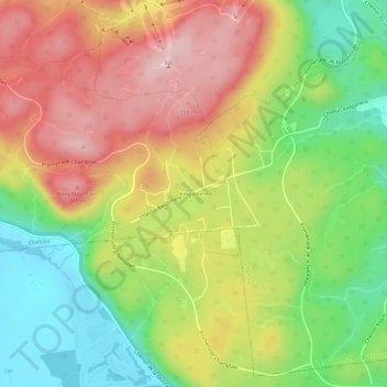
Name: Kingsmere topographic map, elevation, terrain.

Location: Kingsmere, Chelsea, Les Collines-de-l'Outaouais, Outaouais, Quebec, J9J 3S5, Canada (45.46916 -75.86591 45.50916 -75.82591)

Average elevation: 229 m

Minimum elevation: 104 m

Maximum elevation: 360 m

Other topographic maps

Click on a map to view its topography, its elevation and its terrain.

Gear up for your next adventure:

🗺️Ordnance Survey Maps - Essential paper maps for hiking across the UK national parks
🧼Technical Clothing Wash - Special soap to clean and restore waterproof membranes
🔋Solar Power Banks - Keep your GPS and phone charged during multi-day expeditions
Camping Shelters - Emergency and lightweight shelters for outdoor use
🥾Hiking Boot Waterproofing Wax - Maintain the lifespan of your leather trekking boots

As an Amazon Associate, this site earns from qualifying purchases at no extra cost to you.