
Make a donation
Gear up for your next adventure:
As an Amazon Associate, this site earns from qualifying purchases at no extra cost to you.
Crawley topographic map
Click on the map to display elevation.
Make a donation
Gear up for your next adventure:
As an Amazon Associate, this site earns from qualifying purchases at no extra cost to you.
About this map
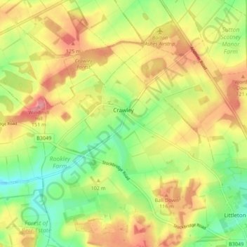
Name: Crawley topographic map, elevation, terrain.
Location: Crawley, Winchester, Hampshire, England, United Kingdom (51.08515 -1.43631 51.12915 -1.35286)
Average elevation: 96 m
Minimum elevation: 51 m
Maximum elevation: 141 m
Hampshire trails, hiking, mountain biking, running and outdoor activities
Make a donation
Gear up for your next adventure:
As an Amazon Associate, this site earns from qualifying purchases at no extra cost to you.
Other topographic maps
Click on a map to view its topography, its elevation and its terrain.
Make a donation
Gear up for your next adventure:
As an Amazon Associate, this site earns from qualifying purchases at no extra cost to you.
Make a donation
Gear up for your next adventure:
As an Amazon Associate, this site earns from qualifying purchases at no extra cost to you.
Farley Chamberlayne
United Kingdom > England > Hampshire > Winchester > Hursley
Average elevation: 106 m
Dodsley Wood
United Kingdom > England > Hampshire > Winchester > East Stratton
Average elevation: 99 m
Store House Gully
United Kingdom > England > Hampshire > Winchester > Fisher's Pond
Average elevation: 45 m
Make a donation
Gear up for your next adventure:
As an Amazon Associate, this site earns from qualifying purchases at no extra cost to you.
Beacon Hill Nature Reserve
United Kingdom > England > Hampshire > Winchester > Exton
Average elevation: 128 m
Make a donation
Gear up for your next adventure:
As an Amazon Associate, this site earns from qualifying purchases at no extra cost to you.
Make a donation
Gear up for your next adventure:
As an Amazon Associate, this site earns from qualifying purchases at no extra cost to you.
Headbourne Worthy
United Kingdom > England > Hampshire > Winchester > Kings Worthy
Average elevation: 66 m
Make a donation
Gear up for your next adventure:
As an Amazon Associate, this site earns from qualifying purchases at no extra cost to you.
Old Winchester Hill Iron Age Fort
United Kingdom > England > Hampshire > Winchester
Average elevation: 123 m
Make a donation
Gear up for your next adventure:
As an Amazon Associate, this site earns from qualifying purchases at no extra cost to you.
Brambridge
United Kingdom > England > Hampshire > Winchester > Colden Common > Brambridge
Average elevation: 37 m
Make a donation
Gear up for your next adventure:
As an Amazon Associate, this site earns from qualifying purchases at no extra cost to you.
Norton Lake
United Kingdom > England > Hampshire > Winchester > Sutton Scotney > Norton
Average elevation: 72 m