
West (Watts) Park topographic map
Interactive map
Click on the map to display elevation.
About this map
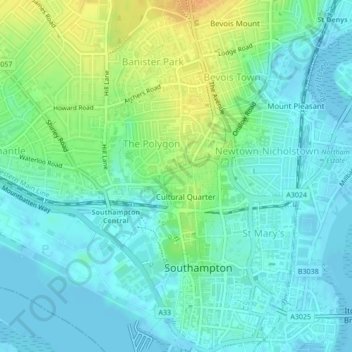
Name: West (Watts) Park topographic map, elevation, terrain.
Average elevation: 10 m
Minimum elevation: -2 m
Maximum elevation: 34 m
Other topographic maps
Click on a map to view its topography, its elevation and its terrain.
Southampton Common
United Kingdom > England > Southampton
Southampton Common, Bassett, Southampton, England, SO15 7NN, United Kingdom
Average elevation: 34 m
Southampton
United Kingdom > England > Southampton
Southampton, South East, England, SO14 2BY, United Kingdom
Average elevation: 38 m
East (Andrews) Park
United Kingdom > England > Southampton
East (Andrews) Park, Cultural Quarter, Bellevue, Southampton, England, SO14 0DA, United Kingdom
Average elevation: 9 m
Southampton Common
United Kingdom > England > Southampton
Southampton Common, Banister Park, Southampton, South East, England, United Kingdom
Average elevation: 28 m
Itchen
United Kingdom > England > Southampton
Itchen, Cobden Bridge, Saint Denys, Southampton, South East, England, SO17 2NR, United Kingdom
Average elevation: 22 m