
Make a donation
Gear up for your next adventure:
As an Amazon Associate, this site earns from qualifying purchases at no extra cost to you.
Hockessin, Delaware topographic map
Click on the map to display elevation.
Make a donation
Gear up for your next adventure:
As an Amazon Associate, this site earns from qualifying purchases at no extra cost to you.
About this map
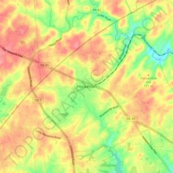
Name: Hockessin, Delaware topographic map, elevation, terrain.
Average elevation: 96 m
Minimum elevation: 41 m
Maximum elevation: 140 m
Make a donation
Gear up for your next adventure:
As an Amazon Associate, this site earns from qualifying purchases at no extra cost to you.
Other topographic maps
Click on a map to view its topography, its elevation and its terrain.
Quaker Hill
United States > Delaware > New Castle County > Hockessin, Delaware
Average elevation: 94 m
Tree Top Valley
United States > Delaware > New Castle County > Hockessin, Delaware > Tree Top Valley
Average elevation: 93 m
Runnymeade
United States > Delaware > New Castle County > Hockessin, Delaware > Runnymeade
Average elevation: 92 m