
Make a donation
Gear up for your next adventure:
As an Amazon Associate, this site earns from qualifying purchases at no extra cost to you.
Estes Lake topographic map
Click on the map to display elevation.
Make a donation
Gear up for your next adventure:
As an Amazon Associate, this site earns from qualifying purchases at no extra cost to you.
About this map
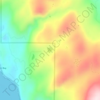
Name: Estes Lake topographic map, elevation, terrain.
Location: Estes Lake, Lake County, Montana, United States (48.00567 -114.03171 48.00717 -114.02944)
Average elevation: 1,068 m
Minimum elevation: 880 m
Maximum elevation: 1,293 m
Make a donation
Gear up for your next adventure:
As an Amazon Associate, this site earns from qualifying purchases at no extra cost to you.
Other topographic maps
Click on a map to view its topography, its elevation and its terrain.
Make a donation
Gear up for your next adventure:
As an Amazon Associate, this site earns from qualifying purchases at no extra cost to you.
North Swan Valley Wildlife Management Area
United States > Montana > Lake County
Average elevation: 1,231 m