
McDonough topographic map
Interactive map
Click on the map to display elevation.
About this map
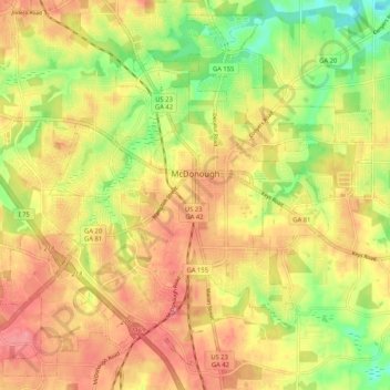
Name: McDonough topographic map, elevation, terrain.
Location: McDonough, Henry County, Georgia, 30253, United States (33.40230 -84.20346 33.48263 -84.09962)
Average elevation: 249 m
Minimum elevation: 200 m
Maximum elevation: 285 m
Other topographic maps
Click on a map to view its topography, its elevation and its terrain.
Ola
United States > Georgia > Henry County
Ola, Henry County, Georgia, United States
Average elevation: 230 m
Stockbridge
United States > Georgia > Henry County
Stockbridge, Henry County, Georgia, United States
Average elevation: 243 m
Locust Grove
United States > Georgia > Henry County > Locust Grove
Locust Grove, Henry County, Georgia, 30248, United States
Average elevation: 230 m