
Zawoja topographic map
Interactive map
Click on the map to display elevation.
About this map
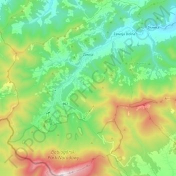
Name: Zawoja topographic map, elevation, terrain.
Average elevation: 829 m
Minimum elevation: 426 m
Maximum elevation: 1,718 m
Other topographic maps
Click on a map to view its topography, its elevation and its terrain.
Grzechynia Dolna
Poland > Lesser Poland Voivodeship > Sucha County > Grzechynia
Average elevation: 452 m
Babia Góra / Babia hora
Poland > Lesser Poland Voivodeship > Sucha County > Zawoja
Gentle from the south, steep from the north, Babia Góra is home to bear, lynx, wolf and other species; as well as alpine flora endemic at this altitude. The first attempts to protect the area were made in the 1930s. In 1933 the Nature Reserve of Babia Góra was established on the Polish side. Later, in 1954,…
Average elevation: 1,395 m