
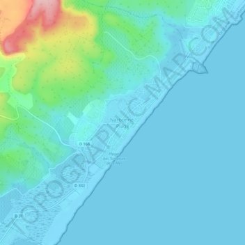
Narbonne-Plage topographic map
Interactive map
Click on the map to display elevation.
About this map
Name: Narbonne-Plage topographic map, elevation, terrain.
Average elevation: 24 m
Minimum elevation: -1 m
Maximum elevation: 170 m
Other topographic maps
Click on a map to view its topography, its elevation and its terrain.
Petit Quatourze
France > Occitanie > Aude > Narbonne
Petit Quatourze, Narbonne, Aude, Occitanie, France métropolitaine, 11100, France
Average elevation: 17 m
Malard-le-Neuf
France > Occitanie > Aude > Narbonne
Malard-le-Neuf, Narbonne, Aude, Occitanie, France métropolitaine, 11100, France
Average elevation: 5 m
Coffre de Pech Redon
France > Occitanie > Aude > Narbonne
Coffre de Pech Redon, Narbonne, Aude, Occitanie, France métropolitaine, 11100, France
Average elevation: 148 m
Malard-le-Vieux
France > Occitanie > Aude > Narbonne
Malard-le-Vieux, Narbonne, Aude, Occitanie, France métropolitaine, 11100, France
Average elevation: 5 m