
Pereiro topographic map
Interactive map
Click on the map to display elevation.
About this map
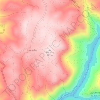
Name: Pereiro topographic map, elevation, terrain.
Location: Pereiro, Alfândega da Fé, Bragança, Portugal (41.30430 -6.87549 41.30440 -6.87539)
Average elevation: 454 m
Minimum elevation: 168 m
Maximum elevation: 582 m
Other topographic maps
Click on a map to view its topography, its elevation and its terrain.