
Manns Peak topographic map
Interactive map
Click on the map to display elevation.
About this map
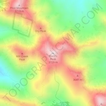
Name: Manns Peak topographic map, elevation, terrain.
Location: Manns Peak, Grand County, Utah, United States (38.51497 -109.22257 38.51507 -109.22247)
Average elevation: 3,427 m
Minimum elevation: 3,123 m
Maximum elevation: 3,739 m
Other topographic maps
Click on a map to view its topography, its elevation and its terrain.
Moab
United States > Utah > Grand County
Moab is just south of the Colorado River, at an elevation of 4,025 feet (1,227 m) on the Colorado Plateau. It is 18 miles (29 km) west of the Utah/Colorado state line. Via U.S. Route 191, it is 31 miles (50 km) south of Interstate 70 at Crescent Junction, and it is 54 miles (87 km) north of Monticello. Via…
Average elevation: 1,357 m
Arches National Park
United States > Utah > Grand County
The park consists of 310.31 square kilometres (76,680 acres; 119.81 sq mi; 31,031 ha) of high desert located on the Colorado Plateau. The highest elevation in the park is 5,653 feet (1,723 m) at Elephant Butte, and the lowest elevation is 4,085 feet (1,245 m) at the visitor center. The park receives an average…
Average elevation: 1,476 m