
Tamaqua topographic map
Interactive map
Click on the map to display elevation.
Tamaqua
Tamaqua's average elevation is 870 feet (270 m) above sea level, but elevations can reach up to 1,000 feet (300 m) above sea level.
About this map
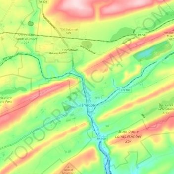
Name: Tamaqua topographic map, elevation, terrain.
Average elevation: 352 m
Minimum elevation: 222 m
Maximum elevation: 521 m
Other topographic maps
Click on a map to view its topography, its elevation and its terrain.
Irving
United States > Pennsylvania > Schuylkill County > Pine Grove Township
Average elevation: 199 m
Blue Mountain
United States > Pennsylvania > Schuylkill County > Washington Township
The ridge of Blue Mountain runs for 150 miles (240 km) through Pennsylvania, reaching an elevation of 2,270 feet (690 m) above sea level just north of the Pennsylvania Turnpike, near the borough of Newburg. Most of the ridgecrest, however, only reaches between 1,400 and 1,700 feet (430 and 520 m) in elevation.…
Average elevation: 226 m
Park Place
United States > Pennsylvania > Schuylkill County > Mahanoy Township
Average elevation: 515 m
Nuremberg
United States > Pennsylvania > Schuylkill County > North Union Township
Average elevation: 377 m
Blue Mountain
United States > Pennsylvania > Schuylkill County > Washington Township
Average elevation: 226 m