
Make a donation
Gear up for your next adventure:
As an Amazon Associate, this site earns from qualifying purchases at no extra cost to you.
Cliff Falls topographic map
Click on the map to display elevation.
Make a donation
Gear up for your next adventure:
As an Amazon Associate, this site earns from qualifying purchases at no extra cost to you.
About this map
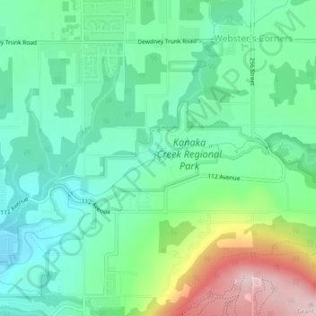
Name: Cliff Falls topographic map, elevation, terrain.
Average elevation: 106 m
Minimum elevation: 8 m
Maximum elevation: 342 m
Make a donation
Gear up for your next adventure:
As an Amazon Associate, this site earns from qualifying purchases at no extra cost to you.
Other topographic maps
Click on a map to view its topography, its elevation and its terrain.
Woodlot 0007
Canada > British Columbia > Metro Vancouver Regional District > Maple Ridge
Average elevation: 322 m
Alouette Lake
Canada > British Columbia > Metro Vancouver Regional District > Maple Ridge
Average elevation: 549 m
Whonnock Lake
Canada > British Columbia > Metro Vancouver Regional District > Maple Ridge
Average elevation: 190 m
Golden Ears
Canada > British Columbia > Metro Vancouver Regional District > Maple Ridge
Average elevation: 189 m
Make a donation
Gear up for your next adventure:
As an Amazon Associate, this site earns from qualifying purchases at no extra cost to you.
Mike Lake
Canada > British Columbia > Metro Vancouver Regional District > Maple Ridge
Average elevation: 297 m
Maple Ridge Park
Canada > British Columbia > Metro Vancouver Regional District > Maple Ridge
Average elevation: 41 m