
Kampung Kasipillay topographic map
Interactive map
Click on the map to display elevation.
About this map
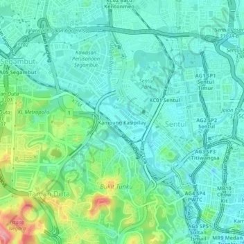
Name: Kampung Kasipillay topographic map, elevation, terrain.
Location: Kampung Kasipillay, Kuala Lumpur, 51000, Malaysia (3.15709 101.66161 3.19709 101.70161)
Average elevation: 54 m
Minimum elevation: 27 m
Maximum elevation: 137 m
Other topographic maps
Click on a map to view its topography, its elevation and its terrain.
Batu Metropolitan Park
Malaysia > Kuala Lumpur > Kuala Lumpur > Kampung Sri Batu
Average elevation: 47 m
KLCC Park
Malaysia > Kuala Lumpur > Kuala Lumpur
The park was designed to showcase a heritage of tropical greenery by integrating man's creation with nature. The park itself contrasts as a calm environment in the midst of the hustle and bustle of the city. The park features many combinations of man-made design such as cements, water features and also natural…
Average elevation: 46 m