Geolocate

Burguillos de Toledo topographic map

Interactive map

Click on the map to display elevation.

About this map

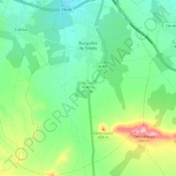
Name: Burguillos de Toledo topographic map, elevation, terrain.

Location: Burguillos de Toledo, Toledo, Castile-La Mancha, Spain (39.74898 -4.02626 39.81552 -3.95960)

Average elevation: 715 m

Minimum elevation: 625 m

Maximum elevation: 938 m

Other topographic maps

Click on a map to view its topography, its elevation and its terrain.

Higueruela

Spain > Castile-La Mancha

Average elevation: 915 m

Carmena

Spain > Castile-La Mancha

Average elevation: 538 m

Villarrobledo

Spain > Castile-La Mancha

Villarrobledo is located in the center of La Mancha, a Spanish region with approximately 26.000 km2 of almost perfect plain, on the eastern half of the Submeseta Meridional with elevation between 600 and 800 meters above sea level, and bordered by the Montes de Toledo, Sierra Morena, Sierra de Alcaraz and…

Average elevation: 773 m

Cuenca

Spain > Castile-La Mancha

The climate of Cuenca is the typical hot-summer Mediterranean climate of Spain's "Meseta" (inner plateau). Winters are relatively cold, but summers are quite hot during the day with occasional cool nights. Spring and autumn seasons are short, with pleasant temperatures during the day but with rather cold…

Average elevation: 1,124 m

Cantón

Spain > Castile-La Mancha > Casas de Haro

Average elevation: 725 m

Peralveche

Spain > Castile-La Mancha

Average elevation: 1,052 m

Ossa de Montiel

Spain > Castile-La Mancha

Average elevation: 925 m

El Bonillo

Spain > Castile-La Mancha

Average elevation: 960 m

El Jetar

Spain > Castile-La Mancha > Puerto Lápice

Average elevation: 652 m

Mira

Spain > Castile-La Mancha

Average elevation: 917 m

Villar de la Encina

Spain > Castile-La Mancha

Average elevation: 836 m

Villanueva de Alcorón

Spain > Castile-La Mancha

Average elevation: 1,252 m

Casas de Ves

Spain > Castile-La Mancha

Average elevation: 685 m

Cózar

Spain > Castile-La Mancha

Average elevation: 846 m

Santa Cruz de la Zarza

Spain > Castile-La Mancha

It is located in the northeast region of the province of Toledo, in the border between Toledo, Madrid and Cuenca far 85, 83 and 101 km of its provincial capitals respectively. Its length is 264.54 km2, and its altitude is 790 m. Bordered by the municipalities of Villamanrique de Tajo and Fuentidueña de Tajo…

Average elevation: 724 m

Trillo

Spain > Castile-La Mancha

Average elevation: 899 m

Ciudad Real

Spain > Castile-La Mancha

The province of Ciudad Real is located in central Spain and is the third largest province in the country with an area of 19,813 km2 (7,650 sq mi). To the north lies the Province of Toledo, to the northeast the Province of Cuenca, to the east the Province of Albacete, to the south lie the Provinces of Córdoba…

Average elevation: 683 m

Añover de Tajo

Spain > Castile-La Mancha

Average elevation: 524 m

Las Majadas

Spain > Castile-La Mancha

Average elevation: 1,310 m

Cardenete

Spain > Castile-La Mancha

Average elevation: 987 m

Toledo

Spain > Castile-La Mancha

Average elevation: 577 m

Campo de Montiel

Spain > Castile-La Mancha

Average elevation: 857 m

Alovera

Spain > Castile-La Mancha

Average elevation: 650 m

Illescas

Spain > Castile-La Mancha

Average elevation: 602 m

Moncalvillo del Huete

Spain > Castile-La Mancha > Huete

Average elevation: 815 m

Uclés

Spain > Castile-La Mancha

Average elevation: 838 m

Herencia

Spain > Castile-La Mancha

Average elevation: 650 m

Mondéjar

Spain > Castile-La Mancha

Average elevation: 788 m

Buenaventura

Spain > Castile-La Mancha

Average elevation: 517 m

Orea

Spain > Castile-La Mancha > Señorío de Molina

Average elevation: 1,603 m

Caraquiz

Spain > Castile-La Mancha

Average elevation: 713 m

Campillo de Altobuey

Spain > Castile-La Mancha

Average elevation: 943 m

Mora

Spain > Castile-La Mancha

Average elevation: 717 m

Algora

Spain > Castile-La Mancha

Average elevation: 1,084 m

Riópar

Spain > Castile-La Mancha

Average elevation: 1,202 m

Bogarra

Spain > Castile-La Mancha

Average elevation: 1,101 m

Zarza de Tajo

Spain > Castile-La Mancha

Average elevation: 732 m

Pantoja

Spain > Castile-La Mancha > La Sagra

Average elevation: 533 m