
Rigside topographic map
Click on the map to display elevation.
Rigside
Drumalbin is a Met Office weather station near Rigside, situated at an elevation of 245 m.
About this map
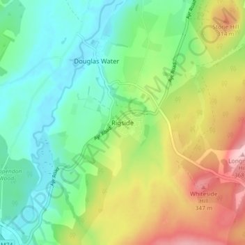
Name: Rigside topographic map, elevation, terrain.
Location: Rigside, South Lanarkshire, Scotland, ML11 9LT, United Kingdom (55.57708 -3.80196 55.61708 -3.76196)
Average elevation: 244 m
Minimum elevation: 176 m
Maximum elevation: 368 m
South Lanarkshire trails, hiking, mountain biking, running and outdoor activities
Other topographic maps
Click on a map to view its topography, its elevation and its terrain.
Langlands Moss Lowland Raised Peatbog
United Kingdom > Scotland > South Lanarkshire > East Kilbride
Average elevation: 204 m
Clyde Valley Family Park's Island
United Kingdom > Scotland > South Lanarkshire > Hazelbank > Birkhill
Average elevation: 119 m
Craignethan Castle
United Kingdom > Scotland > South Lanarkshire > Crossford > Tillietudlem
Average elevation: 121 m
Langlands Moss Local Nature Reserve
United Kingdom > Scotland > South Lanarkshire > East Kilbride
Average elevation: 204 m
Trough Linn Woodlands Project
United Kingdom > Scotland > South Lanarkshire > East Kilbride
Average elevation: 185 m
Low Banks
United Kingdom > Scotland > South Lanarkshire > Lamington > Millhill
Average elevation: 263 m