
Mount Thielsen topographic map
Interactive map
Click on the map to display elevation.
About this map
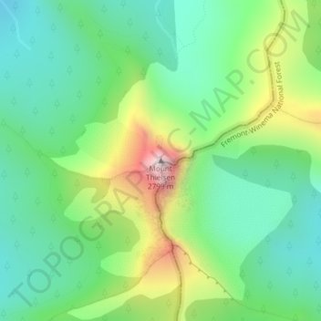
Name: Mount Thielsen topographic map, elevation, terrain.
Location: Mount Thielsen, Douglas County, Oregon, USA (43.15282 -122.06661 43.15292 -122.06651)
Average elevation: 2,243 m
Minimum elevation: 2,005 m
Maximum elevation: 2,753 m
Other topographic maps
Click on a map to view its topography, its elevation and its terrain.
Cascade Locks
USA > Oregon > Cascade Locks
Cascade Locks, Hood River County, Oregon, USA
Average elevation: 101 m
Crook Glacier
Crook Glacier, Broken Top NW Ridge route, Deschutes County, Oregon, USA
Average elevation: 2,347 m
Bend Glacier
Bend Glacier, Broken Top NW Ridge route, Deschutes County, Oregon, USA
Average elevation: 2,350 m
Linn Glacier
Linn Glacier, Pacific Crest Trail, Deschutes County, Oregon, USA
Average elevation: 2,359 m
Glisan Glacier
Glisan Glacier, McNeil Point Trail #600M, Hood River County, Oregon, USA
Average elevation: 2,086 m
Ladd Glacier
Ladd Glacier, Barrett Spur, Hood River County, Oregon, USA
Average elevation: 2,305 m
White River Glacier
White River Glacier, Mountaineer Trail #798, Clackamas County, Oregon, USA
Average elevation: 2,523 m
Jefferson Park Glacier
Jefferson Park Glacier, Pacific Crest Trail, Jefferson County, Oregon, USA
Average elevation: 2,421 m
Palmer Glacier
Palmer Glacier, Mountaineer Trail #798, Clackamas County, Oregon, USA
Average elevation: 2,424 m
Wallowa Mountains
Wallowa Mountains, Wallowa County, Oregon, USA
Average elevation: 2,475 m
Newton Clark Glacier
Newton Clark Glacier, Cooper Spur Trail #600B, Hood River County, Oregon, USA
Average elevation: 2,589 m
Eliot Glacier
Eliot Glacier, Eliot west moraine, Hood River County, Oregon, USA
Average elevation: 2,316 m
Lathrop Glacier
Lathrop Glacier, Mt. Thielsen climber's trail, Douglas County, Oregon, USA
Average elevation: 2,235 m
Lake Hilda
Lake Hilda, National Forest Development Road 4220, Marion County, Oregon, USA
Average elevation: 1,689 m
Milk Creek Glacier
Milk Creek Glacier, Pacific Crest Trail, Jefferson County, Oregon, USA
Average elevation: 2,508 m
Zigzag Glacier
Zigzag Glacier, Mountaineer Trail #798, Clackamas County, Oregon, USA
Average elevation: 2,620 m
Prouty Glacier
Prouty Glacier, South Sister Climber Trail #36, Deschutes County, Oregon, USA
Average elevation: 2,589 m
Diller Glacier
Diller Glacier, climber's trail, Deschutes County, Oregon, USA
Average elevation: 2,416 m
Whitewater Glacier
Whitewater Glacier, Pacific Crest Trail, Jefferson County, Oregon, USA
Average elevation: 2,460 m
Mount Tabor
Mount Tabor, Portland, Multnomah County, Oregon, 97215, USA
Average elevation: 86 m
Carver Glacier
Carver Glacier, South Sister Climber Trail #36, Deschutes County, Oregon, USA
Average elevation: 2,385 m
Kirkpatrick
USA > Oregon > Kirkpatrick
Kirkpatrick, Umatilla County, Oregon, USA
Average elevation: 421 m
Coalman Glacier
Coalman Glacier, Cooper Spur Trail #600B, Hood River County, Oregon, USA
Average elevation: 2,728 m
Clark Glacier
Clark Glacier, South Sister Climber Trail #36, Deschutes County, Oregon, USA
Average elevation: 2,578 m
Thayer Glacier
Thayer Glacier, climber's trail, Deschutes County, Oregon, USA
Average elevation: 2,423 m