
Make a donation
Gear up for your next adventure:
As an Amazon Associate, this site earns from qualifying purchases at no extra cost to you.
Embalse de Canales topographic map
Click on the map to display elevation.
Make a donation
Gear up for your next adventure:
As an Amazon Associate, this site earns from qualifying purchases at no extra cost to you.
About this map
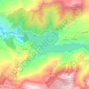
Name: Embalse de Canales topographic map, elevation, terrain.
Average elevation: 1,161 m
Minimum elevation: 791 m
Maximum elevation: 1,543 m
Make a donation
Gear up for your next adventure:
As an Amazon Associate, this site earns from qualifying purchases at no extra cost to you.
Other topographic maps
Click on a map to view its topography, its elevation and its terrain.
Cerro del Zujeiro
España > Andalucía > Comarca de la Vega de Granada > Güéjar Sierra
Average elevation: 1,651 m
Alto de Calar
España > Andalucía > Comarca de la Vega de Granada > Güéjar Sierra
Average elevation: 1,507 m
Castañar de Güéjar Sierra
España > Andalucía > Comarca de la Vega de Granada > Güéjar Sierra
Average elevation: 1,237 m