
Darwell Reservoir topographic map
Interactive map
Click on the map to display elevation.
About this map
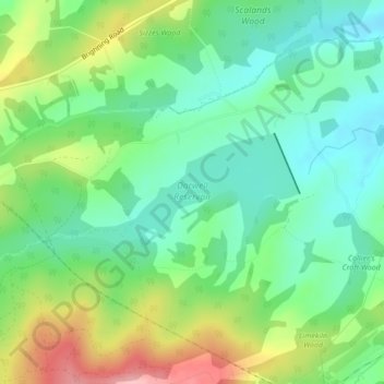
Name: Darwell Reservoir topographic map, elevation, terrain.
Average elevation: 65 m
Minimum elevation: 16 m
Maximum elevation: 157 m
East Sussex trails, hiking, mountain biking, running and outdoor activities
Other topographic maps
Click on a map to view its topography, its elevation and its terrain.
Battle of Hastings
United Kingdom > England > East Sussex > Rother > Catsfield
Battle Abbey was founded by William at the site of the battle. According to 12th-century sources, William made a vow to found the abbey, and the high altar of the church was placed at the site where Harold had died. More likely, the foundation was imposed on William by papal legates in 1070. The topography of…
Average elevation: 60 m
Rye
United Kingdom > England > East Sussex > Rother
The town and its striking surroundings have frequently served as subject for painters, many of whose works are now on display in its art gallery. One of the earliest topographical panoramas, dating from the 17th century when the town was still an island port, is in the style of Hendrick Danckerts and on…
Average elevation: 7 m
Northbridge Street
United Kingdom > England > East Sussex > Rother > Robertsbridge
Average elevation: 40 m
Union Street
United Kingdom > England > East Sussex > Rother > Flimwell > Union Street
Average elevation: 97 m
Rye
United Kingdom > England > East Sussex > Rother
The town and its striking surroundings have frequently served as subject for painters, many of whose works are now on display in its art gallery. One of the earliest topographical panoramas, dating from the 17th century when the town was still an island port, is in the style of Hendrick Danckerts and on…
Average elevation: 7 m
John's Cross
United Kingdom > England > East Sussex > Rother > Mountfield > John's Cross
Average elevation: 53 m