Geolocate

Porto topographic map

Click on the map to display elevation.

About this map

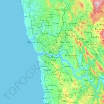
Name: Porto topographic map, elevation, terrain.

Location: Porto, Área Metropolitana do Porto, North, 4000, Portugal (40.98945 -8.77079 41.30945 -8.45079)

Average elevation: 85 m

Minimum elevation: -1 m

Maximum elevation: 526 m

Gear up for your next adventure:

🌄Outdoor Binoculars - Compact binoculars for landscape observation
🔭Compact Hiking Binoculars - Lightweight optics for scouting terrain and spotting wildlife
🛰️Handheld GPS Devices - Reliable GPS units for hiking and outdoor navigation
🥫Expedition Meals - Lightweight, high-calorie nutrition for long-distance hikers
🛌Sleeping Bags - Warm and packable sleeping bags for outdoor nights

As an Amazon Associate, this site earns from qualifying purchases at no extra cost to you.