Geolocate

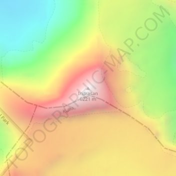
Indrasan topographic map

Click on the map to display elevation.

Indrasan

Mount Indrasan is located at an altitude of 6221 metres above sea level in Kullu district, Himachal Pradesh. Mt. Indrasan is considered as the most difficult mountain to climb in the Pir Panjal range of the Himalayas because of the challenges involved in scaling it. It was first climbed on October 13, 1962, by an expedition organized by Kyoto University Alpine Club, Kyoto, Japan.

Wikipedia (CC-BY-SA 3.0)

About this map

Name: Indrasan topographic map, elevation, terrain.

Location: Indrasan, Lahul, Lahaul and Spiti, Himachal Pradesh, India (32.21374 77.39639 32.21384 77.39649)

Average elevation: 5,374 m

Minimum elevation: 4,527 m

Maximum elevation: 6,189 m

Other topographic maps

Click on a map to view its topography, its elevation and its terrain.
Chandratal Lake

India > Himachal Pradesh > Lahul

Average elevation: 4,403 m

Suraj Tal

India > Himachal Pradesh > Lahul

Average elevation: 5,007 m

Chandratal Lake

India > Himachal Pradesh > Lahul

Average elevation: 4,403 m

Gear up for your next adventure:

🥾Women's Waterproof Hiking Boots - High-performance trekking boots designed for all-weather comfort
🎒Multi-day Trekking Packs - Large capacity backpacks for wild camping and long-distance trails
🧼Camping Hygiene Kits - Compact hygiene essentials for outdoor stays
🎒Hiking Daypacks - Compact backpacks ideal for short hikes and excursions
📐Altimeters & Barometers - Tools for measuring altitude and air pressure

As an Amazon Associate, this site earns from qualifying purchases at no extra cost to you.