
Thank you for supporting this site ❤️
Make a donation
Make a donation
Gear up for your next adventure:
As an Amazon Associate, this site earns from qualifying purchases at no extra cost to you.
Kapenguria topographic map
Click on the map to display elevation.
Thank you for supporting this site ❤️
Make a donation
Make a donation
Gear up for your next adventure:
As an Amazon Associate, this site earns from qualifying purchases at no extra cost to you.
About this map
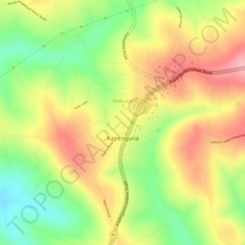
Name: Kapenguria topographic map, elevation, terrain.
Location: Kapenguria, West Pokot Subcounty, West Pokot, Rift Valley, Kenya (1.24582 35.08648 1.26202 35.10012)
Average elevation: 2,036 m
Minimum elevation: 1,958 m
Maximum elevation: 2,099 m
Thank you for supporting this site ❤️
Make a donation
Make a donation
Gear up for your next adventure:
As an Amazon Associate, this site earns from qualifying purchases at no extra cost to you.
Other topographic maps
Click on a map to view its topography, its elevation and its terrain.