
Make a donation
Gear up for your next adventure:
As an Amazon Associate, this site earns from qualifying purchases at no extra cost to you.
Castro topographic map
Click on the map to display elevation.
Make a donation
Gear up for your next adventure:
As an Amazon Associate, this site earns from qualifying purchases at no extra cost to you.
About this map
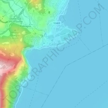
Name: Castro topographic map, elevation, terrain.
Location: Castro, Bergamo, Lombardy, 24063, Italy (45.79015 10.05077 45.81074 10.08041)
Average elevation: 235 m
Minimum elevation: 181 m
Maximum elevation: 565 m
Make a donation
Gear up for your next adventure:
As an Amazon Associate, this site earns from qualifying purchases at no extra cost to you.
Other topographic maps
Click on a map to view its topography, its elevation and its terrain.
Make a donation
Gear up for your next adventure:
As an Amazon Associate, this site earns from qualifying purchases at no extra cost to you.
Make a donation
Gear up for your next adventure:
As an Amazon Associate, this site earns from qualifying purchases at no extra cost to you.
Fara Olivana
Italy > Lombardy > Bergamo > Fara Olivana con Sola > Fara Olivana
Average elevation: 111 m
Pizzo Coca
Italy > Lombardy > Bergamo > Valbondione
The Alps are split into five climate zones, each with a different kind of environment. The climate, plant life and animal life vary on different sections or zones of the mountain such as Pizzo Coca. The initial altitude at Val Seriana, one of the recommended southern access points, is 1,100 meters and part of…
Average elevation: 2,380 m
Make a donation
Gear up for your next adventure:
As an Amazon Associate, this site earns from qualifying purchases at no extra cost to you.