Geolocate

Wales of Harford topographic map

Interactive map

Click on the map to display elevation.

About this map

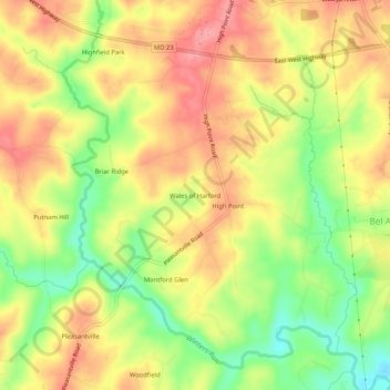
Name: Wales of Harford topographic map, elevation, terrain.

Location: Wales of Harford, Harford County, Maryland, 21047, United States (39.54011 -76.44635 39.58011 -76.40635)

Average elevation: 138 m

Minimum elevation: 84 m

Maximum elevation: 179 m

Other topographic maps

Click on a map to view its topography, its elevation and its terrain.

Highfield Park

United States > Maryland > Harford County > Bel Air

Highfield Park, Bel Air, Harford County, Maryland, United States

Average elevation: 153 m

Bel Air

United States > Maryland > Harford County

Bel Air, Harford County, Maryland, 21014, United States

Average elevation: 103 m

Edgewood

United States > Maryland > Harford County

Edgewood, Harford County, Maryland, 21040, United States

Average elevation: 12 m

Havre de Grace

United States > Maryland > Harford County

Havre de Grace, Harford County, Maryland, 21078, United States

Average elevation: 24 m

Aberdeen

United States > Maryland > Harford County > Aberdeen

Aberdeen, Harford County, Maryland, 21001-1734, United States

Average elevation: 36 m

Meadow Springs

United States > Maryland > Harford County > Meadow Springs

Meadow Springs, Harford County, Maryland, 21028, United States

Average elevation: 108 m