Geolocate

Waterford topographic map

Click on the map to display elevation.

About this map

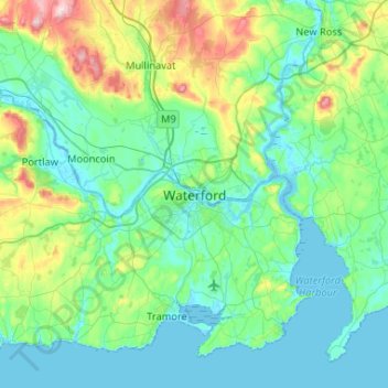
Name: Waterford topographic map, elevation, terrain.

Location: Waterford, County Waterford, Munster, X91 XH5R, Ireland (52.10100 -7.27191 52.42100 -6.95191)

Average elevation: 57 m

Minimum elevation: -4 m

Maximum elevation: 312 m

Gear up for your next adventure:

🖼️Topographic Map Art - Decorative 3D-effect posters of famous UK peaks and regions
📦Compression Sacks - Reduce backpack volume efficiently
👕Technical Hiking Tees - Moisture-management for high-exertion climbs
🔋Power Banks - Portable chargers for long outdoor trips
🕶️Glacier Goggles - Maximum protection for high-altitude snow topography

As an Amazon Associate, this site earns from qualifying purchases at no extra cost to you.