
Oudsbergen topographic map
Interactive map
Click on the map to display elevation.
About this map
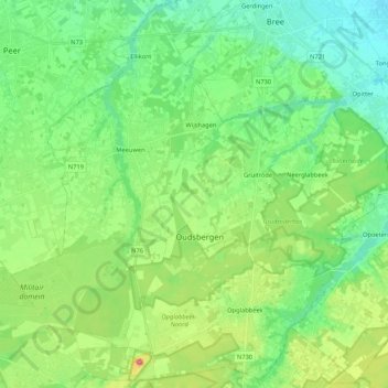
Name: Oudsbergen topographic map, elevation, terrain.
Location: Oudsbergen, Maaseik, Limburg, Flanders, Belgium (51.01877 5.45438 51.14635 5.66607)
Average elevation: 69 m
Minimum elevation: 34 m
Maximum elevation: 155 m
Other topographic maps
Click on a map to view its topography, its elevation and its terrain.
Kleine-Brogel
Belgium > Limburg > Maaseik > Peer
Kleine-Brogel, Peer, Maaseik, Limburg, Flanders, Belgium
Average elevation: 52 m
Houthalen
Belgium > Limburg > Maaseik > Houthalen-Helchteren
Houthalen, Houthalen-Helchteren, Maaseik, Limburg, Flanders, 3530, Belgium
Average elevation: 58 m
Dilsen-Stokkem
Dilsen-Stokkem, Maaseik, Limburg, 3650, Belgium
Average elevation: 46 m