Geolocate

Midleton topographic map

Click on the map to display elevation.

About this map

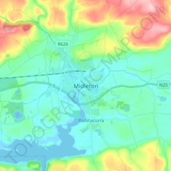
Name: Midleton topographic map, elevation, terrain.

Location: Midleton, County Cork, Munster, P25 DT04, Ireland (51.87427 -8.21010 51.95427 -8.13010)

Average elevation: 42 m

Minimum elevation: -12 m

Maximum elevation: 164 m

Gear up for your next adventure:

🔋Lithium AA Batteries - Long-lasting power that performs well in cold mountain weather
📸Action Camera Chest Mounts - Record your ascent following topographic paths hands-free
🐕Dog Hiking Gear - Equipment for hiking safely with dogs
GPS Outdoor Watches - Watches with GPS tracking for hiking and exploration
🧥Packable Down Jackets - Lightweight warmth that compresses small in your bag

As an Amazon Associate, this site earns from qualifying purchases at no extra cost to you.