
River Soar topographic map
Interactive map
Click on the map to display elevation.
About this map
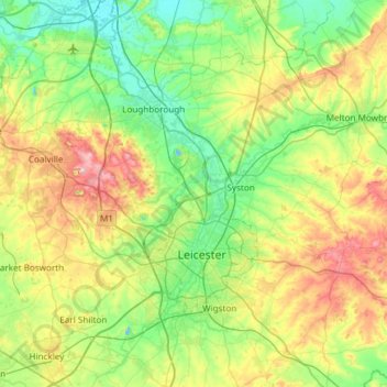
Name: River Soar topographic map, elevation, terrain.
Location: River Soar, City of Leicester, England, United Kingdom (52.51177 -1.37033 52.87335 -1.10048)
Average elevation: 101 m
Minimum elevation: 28 m
Maximum elevation: 269 m
Other topographic maps
Click on a map to view its topography, its elevation and its terrain.
Abbey Park
United Kingdom > England > City of Leicester > Leicester
Abbey Park, St Matthew's, Leicester, City of Leicester, England, United Kingdom
Average elevation: 62 m
Nelson Mandela Park
United Kingdom > England > City of Leicester > Leicester
Nelson Mandela Park, Bede Island, Leicester, City of Leicester, England, United Kingdom
Average elevation: 71 m