
Aljustrel topographic map
Interactive map
Click on the map to display elevation.
About this map
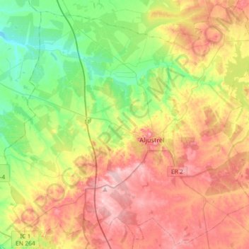
Name: Aljustrel topographic map, elevation, terrain.
Location: Aljustrel, Beja, Baixo Alentejo, Alentejo, Portugal (37.78007 -8.33619 38.00028 -8.04813)
Average elevation: 140 m
Minimum elevation: 49 m
Maximum elevation: 249 m
Other topographic maps
Click on a map to view its topography, its elevation and its terrain.
Vidigueira
Vidigueira, Beja, Baixo Alentejo, Alentejo, Portugal
Average elevation: 191 m
Santiago do Cacém
Portugal > Alentejo > Santiago do Cacém, Santa Cruz e São Bartolomeu da Serra
Santiago do Cacém, Santiago do Cacém, Santa Cruz e São Bartolomeu da Serra, STC, Setúbal, Alentejo Litoral, Alentejo, Portugal
Average elevation: 140 m
Paul do Boquilobo Nature Reserve
Portugal > Alentejo > Azinhaga
Paul do Boquilobo Nature Reserve, Estrada dos Lazaros, Azinhaga, Golegã, Santarém, Lezíria do Tejo, Alentejo, 2140-999, Portugal
Average elevation: 27 m