
Mawanella topographic map
Interactive map
Click on the map to display elevation.
Mawanella
Mawanella belongs to the Tropical Evergreen region of central Sri Lanka. The altitude of the area varies from 180m to 260 m above sea level. The average annual rainfall lies between 2500 and 4500 ml, and temperature of the region ranges between 22 degrees and 35 degrees Celsius. It receives most of the rain from Southwest Monsoon. The average wind speed has been measured to be approximately 7.2 km/hour and humidity in the range lies between 57% and 90%. The whole region is mountainous, but the most famous mountain is the Bathalegala or Bible Rock. Devanagala and Alagalla are another two mountains in the area. There is also a waterway called Maa Oya running very close to the town and there is a village called Bootawa, where two waterways called Maa Oya and Higulu Oya are joining near a Bridge called Bootawa Bridge situated in Mawanella to Rambukkana Road. The historic Mawanella Bridge built to cross the Maha Oya by the British, during their colonial ruler. A modern concrete bridge was constructed in 2005, immediately north of the old bridge.
About this map
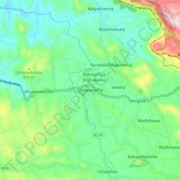
Name: Mawanella topographic map, elevation, terrain.
Average elevation: 239 m
Minimum elevation: 89 m
Maximum elevation: 643 m
Other topographic maps
Click on a map to view its topography, its elevation and its terrain.
Sinharaja Forest Reserve
Sri Lanka > Sabaragamuwa Province > Palinda-Nuwara (Baduraliya) DS Division
Average elevation: 374 m
Sinharaja Forest Reserve
Sri Lanka > Sabaragamuwa Province > Palinda-Nuwara (Baduraliya) DS Division
Average elevation: 374 m