
Musi River topographic map
Interactive map
Click on the map to display elevation.
About this map
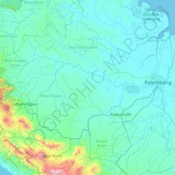
Name: Musi River topographic map, elevation, terrain.
Location: Musi River, Sumatra, Indonesia (-3.78917 102.49611 -2.33736 104.95725)
Average elevation: 146 m
Minimum elevation: -3 m
Maximum elevation: 2,981 m
Other topographic maps
Click on a map to view its topography, its elevation and its terrain.
Malang
Indonesia > East Java > Kota Malang > Malang
The city was capital city of Singhasari in 1222, then transferred to Dutch colony. Malang was modernized under the Dutch; its mild climate which results from its elevation, along with its proximity to the major port of Surabaya, made it a popular destination for the Dutch and other Europeans. Malang began to…
Average elevation: 657 m
Bandung
Bandung (Sundanese: ᮘᮔ᮪ᮓᮥᮀ, romanized: Bandung, Sundanese pronunciation: [ˈbandʊŋ]; /ˈbɑːndʊŋ/) is the capital city of the Indonesian province of West Java. It has a population of 2,452,943 within its city limits according to the official estimates as at mid 2021, making it the fourth most…
Average elevation: 879 m
Bali Island
Bali's central mountains include several peaks over 2,000 metres (6,600 feet) in elevation and active volcanoes such as Mount Batur. The highest is Mount Agung (3,031 m; 9,944 ft), known as the "mother mountain", which is an active volcano rated as one of the world's most likely sites for a massive eruption…
Average elevation: 357 m
Pantai Drini
Indonesia > Special Region of Yogyakarta > Gunung Kidul Regency > Banjarejo
Average elevation: 20 m
Sungai Code
Indonesia > Special Region of Yogyakarta > Sleman Regency > Yogyakarta
Average elevation: 110 m
Taman Alun-Alun Kaliwungu
Indonesia > Central Java > Kendal > Kendal > Sikopek Kulon
Average elevation: 15 m
Kepanjen
Indonesia > East Java > Kabupaten Malang
Kepanjen is located in south center of Malang Regency. Kepanjen has an average altitude of 336 metres (1,102 ft) above sea level. Kepanjen is surrounded by three large mountains: Mount Kawi, Mount Semeru and Southern Malang Mountains.
Average elevation: 337 m
Dusun Cilangkap, Desa Cisempur, Kec. Cibalong, Kab. Tasikmalaya
Indonesia > West Java > Tasikmalaya > Cisempur
Average elevation: 198 m
RW 11 Kelurahan Merjosari Kecamatan Lowokwaru Kota Malang
Indonesia > East Java > Kota Malang > Malang
Average elevation: 597 m