Geolocate

Ballesteros topographic map

Click on the map to display elevation.

About this map

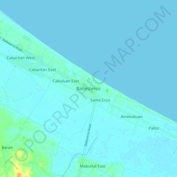
Name: Ballesteros topographic map, elevation, terrain.

Location: Ballesteros, Cagayan, Cagayan Valley, 3516, Philippines (18.36943 121.47475 18.44943 121.55475)

Average elevation: 3 m

Minimum elevation: -1 m

Maximum elevation: 34 m

Other topographic maps

Click on a map to view its topography, its elevation and its terrain.

Santa Praxedes

Philippines > Cagayan

Average elevation: 157 m

Gear up for your next adventure:

🔭Compact Hiking Binoculars - Lightweight optics for scouting terrain and spotting wildlife
🌦️Portable Weather Meters - Handheld tools for monitoring weather conditions
🕶️Polarized Sunglasses - Reduces glare from snow and water when reading terrain
🔦LED Camping Lanterns - Illumination for reading maps inside your tent at night
🍳Camping Stoves - Compact stoves for outdoor cooking

As an Amazon Associate, this site earns from qualifying purchases at no extra cost to you.