
Make a donation
Gear up for your next adventure:
As an Amazon Associate, this site earns from qualifying purchases at no extra cost to you.
Northvale topographic map
Click on the map to display elevation.
Make a donation
Gear up for your next adventure:
As an Amazon Associate, this site earns from qualifying purchases at no extra cost to you.
Northvale
The borough of Northvale was formed on March 15, 1916, from the remaining portions of Harrington Township, based on the results of a referendum held on April 4, 1916. With the creation of Northvale, Harrington Township was dissolved. Portions of Northvale were transferred to create the borough of Rockleigh, as of March 13, 1923. The borough's name derives from its location and topography.
Make a donation
Gear up for your next adventure:
As an Amazon Associate, this site earns from qualifying purchases at no extra cost to you.
About this map
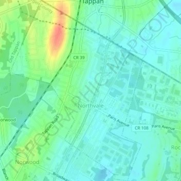
Name: Northvale topographic map, elevation, terrain.
Location: Northvale, Bergen County, New Jersey, 07647, United States (40.99529 -73.96525 41.02263 -73.93834)
Average elevation: 19 m
Minimum elevation: 6 m
Maximum elevation: 55 m
Make a donation
Gear up for your next adventure:
As an Amazon Associate, this site earns from qualifying purchases at no extra cost to you.
Other topographic maps
Click on a map to view its topography, its elevation and its terrain.
Make a donation
Gear up for your next adventure:
As an Amazon Associate, this site earns from qualifying purchases at no extra cost to you.
Make a donation
Gear up for your next adventure:
As an Amazon Associate, this site earns from qualifying purchases at no extra cost to you.
Make a donation
Gear up for your next adventure:
As an Amazon Associate, this site earns from qualifying purchases at no extra cost to you.
Make a donation
Gear up for your next adventure:
As an Amazon Associate, this site earns from qualifying purchases at no extra cost to you.
Ridgefield Park
United States > New Jersey > Bergen County > Ridgefield Park > Ridgefield Park
Average elevation: 21 m
Make a donation
Gear up for your next adventure:
As an Amazon Associate, this site earns from qualifying purchases at no extra cost to you.