
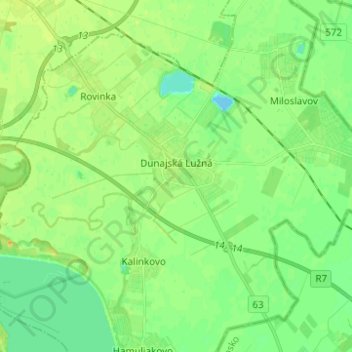
Dunajská Lužná topographic map
Interactive map
Click on the map to display elevation.
About this map
Name: Dunajská Lužná topographic map, elevation, terrain.
Average elevation: 129 m
Minimum elevation: 118 m
Maximum elevation: 142 m
There is a large Roman Catholic community in Dunajská Lužná with the Church, devoted to "The Elevation of the Holy Cross". Besides Roman Catholics there are also Lutherans and other religions.
Other topographic maps
Click on a map to view its topography, its elevation and its terrain.
Veľký Biel
Slovakia > Region of Bratislava > District of Senec
Veľký Biel, District of Senec, Region of Bratislava, 900 24, Slovakia
Average elevation: 130 m
Veľkobielske jazero "Šutrovka"
Slovakia > Region of Bratislava > District of Senec > Veľký Biel
Veľkobielske jazero "Šutrovka", Veľký Biel, District of Senec, Region of Bratislava, Slovakia
Average elevation: 127 m
Bernolákovo
Slovakia > Region of Bratislava > District of Senec > Bernolákovo
Bernolákovo, District of Senec, Region of Bratislava, 900 27, Slovakia
Average elevation: 133 m
Senec
Slovakia > Region of Bratislava > District of Senec
Senec, District of Senec, Region of Bratislava, Slovakia
Average elevation: 134 m