
Miskolc topographic map
Interactive map
Click on the map to display elevation.
Miskolc
The lowest areas are the banks of the river Sajó, with an altitude of 110–120 m (360–390 ft). The area belongs to the Great Plain region and is made up of sedimentary rocks. Between the Avas hill and Diósgyőr lies the hilly area of the Lower Bükk (250–300 m or 820–980 ft) consisting of sandstone, marl, clay, layers of coal, from the tertiary period, and volcanic rocks from the Miocene.
About this map
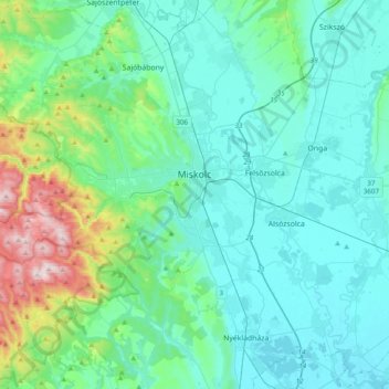
Name: Miskolc topographic map, elevation, terrain.
Average elevation: 194 m
Minimum elevation: 94 m
Maximum elevation: 710 m
Other topographic maps
Click on a map to view its topography, its elevation and its terrain.
Szentistvánbaksa
Hungary > Borsod-Abaúj-Zemplén > Szentistvánbaksa > Szentistvánbaksa
Average elevation: 163 m