
Eggenfelden topographic map
Interactive map
Click on the map to display elevation.
About this map
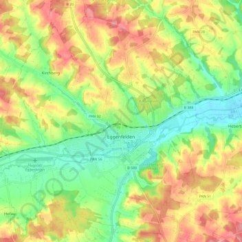
Name: Eggenfelden topographic map, elevation, terrain.
Location: Eggenfelden, Landkreis Rottal-Inn, Beieren, 84307, Duitsland (48.36985 12.69863 48.44634 12.79913)
Average elevation: 440 m
Minimum elevation: 392 m
Maximum elevation: 494 m
Other topographic maps
Click on a map to view its topography, its elevation and its terrain.
Simbach
Duitsland > Beieren > Landkreis Rottal-Inn
Simbach, Landkreis Rottal-Inn, Beieren, 84359, Duitsland
Average elevation: 425 m
Golling
Duitsland > Beieren > Landkreis Rottal-Inn > Simbach > Kirchberg am Inn
Golling, Kirchberg am Inn, Simbach, Landkreis Rottal-Inn, Beieren, 84359, Duitsland
Average elevation: 397 m