
Dykes of Gray topographic map
Interactive map
Click on the map to display elevation.
About this map
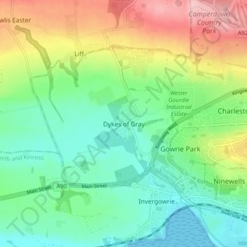
Name: Dykes of Gray topographic map, elevation, terrain.
Location: Dykes of Gray, Dundee City, Scotland, DD2 5GS, United Kingdom (56.45181 -3.09055 56.49181 -3.05055)
Average elevation: 57 m
Minimum elevation: 0 m
Maximum elevation: 164 m
Other topographic maps
Click on a map to view its topography, its elevation and its terrain.
Dundee
United Kingdom > Scotland > Dundee City
Dundee sits on the north bank of the Firth of Tay on the eastern, North Sea Coast of Scotland. The city lies 36.1 miles (58 km) NNE of Edinburgh and 360.6 miles (580 km) NNW of London. The built-up area occupies a roughly rectangular shape 8.3 miles (13 km) long by 2.5 miles (4 km) wide, aligned in an east to…
Average elevation: 82 m