
Elgin topographic map
Click on the map to display elevation.
About this map
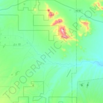
Name: Elgin topographic map, elevation, terrain.
Location: Elgin, Santa Cruz County, Arizona, United States (31.57759 -110.62089 31.72378 -110.45172)
Average elevation: 1,484 m
Minimum elevation: 1,350 m
Maximum elevation: 1,965 m
Other topographic maps
Click on a map to view its topography, its elevation and its terrain.
Nogales
United States > Arizona > Santa Cruz County
The city is at an elevation of 3,829 feet (1,167 m).
Average elevation: 1,192 m
Nogales
United States > Arizona > Santa Cruz County
The city is at an elevation of 3,829 ft (1,167 m).
Average elevation: 1,192 m