
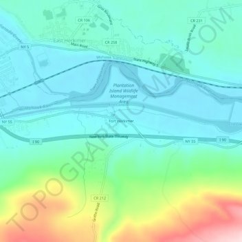
Fort Herkimer topographic map
Interactive map
Click on the map to display elevation.
About this map
Name: Fort Herkimer topographic map, elevation, terrain.
Average elevation: 177 m
Minimum elevation: 107 m
Maximum elevation: 392 m
Other topographic maps
Click on a map to view its topography, its elevation and its terrain.
Village of Mohawk
United States > New York > Herkimer County > Town of German Flatts
Village of Mohawk, Town of German Flatts, Herkimer County, New York, United States
Average elevation: 148 m
Dennison Corners
United States > New York > Herkimer County > Town of German Flatts
Dennison Corners, Town of German Flatts, Herkimer County, New York, 13407, United States
Average elevation: 404 m
Edicks
United States > New York > Herkimer County > Town of German Flatts
Edicks, Town of German Flatts, Herkimer County, New York, United States
Average elevation: 355 m
South Ilion
United States > New York > Herkimer County > Town of German Flatts
South Ilion, Town of German Flatts, Herkimer County, New York, United States
Average elevation: 239 m
Days Rock
United States > New York > Herkimer County > Town of German Flatts
Days Rock, Town of German Flatts, Herkimer County, New York, 13407, United States
Average elevation: 317 m
Village of Ilion
United States > New York > Herkimer County > Town of German Flatts
Village of Ilion, Town of German Flatts, Herkimer County, New York, 13357, United States
Average elevation: 151 m