
Make a donation
Gear up for your next adventure:
As an Amazon Associate, this site earns from qualifying purchases at no extra cost to you.
Bailly topographic map
Click on the map to display elevation.
Make a donation
Gear up for your next adventure:
As an Amazon Associate, this site earns from qualifying purchases at no extra cost to you.
Bailly
L'Oise prend sa source en Belgique, à 309 mètres d'altitude, dans l'ancienne commune de Forges et se jette dans la Seine à 20 mètres d'altitude, au Pointil en rive droite et en aval du centre de Conflans-Sainte-Honorine dans le département des Yvelines. D'une longueur 341 kilomètres, elle est presque entièrement navigable et bordée de canaux sur 104 kilomètres.
Make a donation
Gear up for your next adventure:
As an Amazon Associate, this site earns from qualifying purchases at no extra cost to you.
About this map
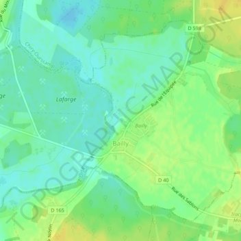
Name: Bailly topographic map, elevation, terrain.
Average elevation: 41 m
Minimum elevation: 31 m
Maximum elevation: 53 m
Make a donation
Gear up for your next adventure:
As an Amazon Associate, this site earns from qualifying purchases at no extra cost to you.
Other topographic maps
Click on a map to view its topography, its elevation and its terrain.
Make a donation
Gear up for your next adventure:
As an Amazon Associate, this site earns from qualifying purchases at no extra cost to you.