
Rötz topographic map
Interactive map
Click on the map to display elevation.
About this map
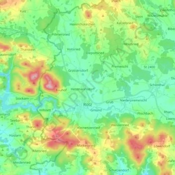
Name: Rötz topographic map, elevation, terrain.
Location: Rötz, Landkreis Cham, Bavaria, 92444, Germany (49.29270 12.47767 49.41427 12.58695)
Average elevation: 504 m
Minimum elevation: 421 m
Maximum elevation: 699 m
Other topographic maps
Click on a map to view its topography, its elevation and its terrain.
Hetzmannsdorf
Germany > Bavaria > Landkreis Cham > Rötz
Hetzmannsdorf, Rötz, Landkreis Cham, Bavaria, 92444, Germany
Average elevation: 472 m
Roding
Germany > Bavaria > Landkreis Cham
Roding, Landkreis Cham, Bavaria, 93426, Germany
Average elevation: 430 m
Beckenhöhle
Germany > Bavaria > Landkreis Cham > Waldmünchen
Beckenhöhle, Waldmünchen, Landkreis Cham, Bavaria, 93449, Germany
Average elevation: 546 m