Geolocate

Petit Coo topographic map

Click on the map to display elevation.

About this map

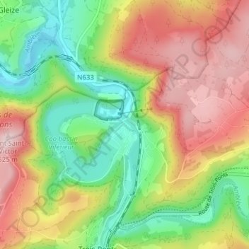
Name: Petit Coo topographic map, elevation, terrain.

Location: Petit Coo, Stavelot, Verviers, Liège, Wallonia, 4970, Belgium (50.37271 5.85704 50.41271 5.89704)

Average elevation: 349 m

Minimum elevation: 207 m

Maximum elevation: 517 m

Other topographic maps

Click on a map to view its topography, its elevation and its terrain.

Francorchamps

Belgium > Liège > Verviers > Stavelot

Average elevation: 489 m

Gear up for your next adventure:

📍Handheld GPS Navigators - Reliable satellite navigation for hiking and off-road exploration
🧤Waterproof Overmitts - Extreme weather protection for hikers and mountaineers
🔦LED Camping Lanterns - Illumination for reading maps inside your tent at night
🌂Windproof Trekking Umbrellas - Surprising but effective rain protection on low-wind trails
🧭Emergency Beacons - Safety beacons for remote outdoor locations

As an Amazon Associate, this site earns from qualifying purchases at no extra cost to you.