Geolocate

Chowk topographic map

Click on the map to display elevation.

About this map
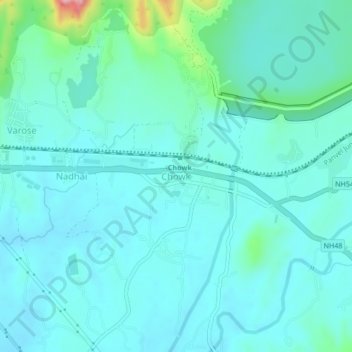
Name: Chowk topographic map, elevation, terrain.

Location: Chowk, Khalapur Taluka, Raigad, Maharashtra, India (18.88055 73.21979 18.92055 73.25979)

Average elevation: 53 m

Minimum elevation: 25 m

Maximum elevation: 208 m

Other topographic maps

Click on a map to view its topography, its elevation and its terrain.

Khalapur Gaon

India > Maharashtra > Khalapur Taluka

Average elevation: 66 m

Morbe Dam

India > Maharashtra > Khalapur Taluka > Chowk

Average elevation: 61 m

Patalganga

India > Maharashtra > Khalapur Taluka > Jambrung

Average elevation: 95 m

Gear up for your next adventure:

🧢Thermal Beanie Hats - Prevent heat loss from the head in windy summit conditions
🍳Camping Stoves - Compact stoves for outdoor cooking
🛌Insulated Sleeping Mats - Crucial thermal protection when sleeping on cold, uneven ground
🔦Waterproof LED Headlamps - Hands-free lighting for evening treks and emergency navigation
🎒Hiking Backpacks - Comfortable backpacks for day hikes and multi-day treks

As an Amazon Associate, this site earns from qualifying purchases at no extra cost to you.