
Make a donation
Gear up for your next adventure:
As an Amazon Associate, this site earns from qualifying purchases at no extra cost to you.
Oil City topographic map
Click on the map to display elevation.
Make a donation
Gear up for your next adventure:
As an Amazon Associate, this site earns from qualifying purchases at no extra cost to you.
About this map
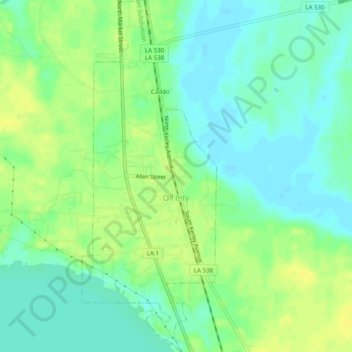
Name: Oil City topographic map, elevation, terrain.
Location: Oil City, Caddo Parish, Louisiana, 71061, United States (32.72585 -93.98475 32.76724 -93.96590)
Average elevation: 57 m
Minimum elevation: 48 m
Maximum elevation: 67 m
Make a donation
Gear up for your next adventure:
As an Amazon Associate, this site earns from qualifying purchases at no extra cost to you.
Other topographic maps
Click on a map to view its topography, its elevation and its terrain.
Make a donation
Gear up for your next adventure:
As an Amazon Associate, this site earns from qualifying purchases at no extra cost to you.
Make a donation
Gear up for your next adventure:
As an Amazon Associate, this site earns from qualifying purchases at no extra cost to you.
Cynthia Park
United States > Louisiana > Caddo Parish > Shreveport > Cynthia Park
Average elevation: 71 m