
Make a donation
Gear up for your next adventure:
As an Amazon Associate, this site earns from qualifying purchases at no extra cost to you.
Labé topographic map
Click on the map to display elevation.
Make a donation
Gear up for your next adventure:
As an Amazon Associate, this site earns from qualifying purchases at no extra cost to you.
Labé
Labé has a tropical savanna climate (Köppen climate classification Aw) with extreme temperature differences between day and night due to the city’s altitude of over 1,000 metres or 3,280 feet. It is as hot by day as the coast of Guinea all year round, but cold to comfortable at night due to lower heat storage in thinner air. About 1,550 millimetres or 61 inches of rain fall annually, almost all between late April and early November.
Make a donation
Gear up for your next adventure:
As an Amazon Associate, this site earns from qualifying purchases at no extra cost to you.
About this map
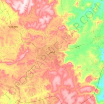
Name: Labé topographic map, elevation, terrain.
Location: Labé, Labé-Centre, Labé Prefecture, Labé Region, Guinea (11.16300 -12.44225 11.48300 -12.12225)
Average elevation: 988 m
Minimum elevation: 697 m
Maximum elevation: 1,263 m
Make a donation
Gear up for your next adventure:
As an Amazon Associate, this site earns from qualifying purchases at no extra cost to you.