
Goch topographic map
Click on the map to display elevation.
About this map
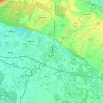
Name: Goch topographic map, elevation, terrain.
Location: Goch, Kreis Kleve, North Rhine-Westphalia, 47574, Germany (51.61380 6.02605 51.74803 6.22933)
Average elevation: 24 m
Minimum elevation: 9 m
Maximum elevation: 68 m
Other topographic maps
Click on a map to view its topography, its elevation and its terrain.
An der Manier
Germany > North Rhine-Westphalia > Kreis Kleve > Kalkar > Neulouisendorf
Average elevation: 30 m