
Oberweißenbrunn topographic map
Interactive map
Click on the map to display elevation.
About this map
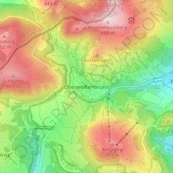
Name: Oberweißenbrunn topographic map, elevation, terrain.
Average elevation: 697 m
Minimum elevation: 518 m
Maximum elevation: 890 m
Other topographic maps
Click on a map to view its topography, its elevation and its terrain.
Unterweißenbrunn
Deutschland > Bayern > Landkreis Rhön-Grabfeld > Bischofsheim i.d.Rhön
Unterweißenbrunn, Bischofsheim i.d.Rhön, Landkreis Rhön-Grabfeld, Bayern, 97653, Deutschland
Average elevation: 476 m
Sinnquellgebiet und Arnsbergsüdhang
Deutschland > Bayern > Landkreis Rhön-Grabfeld > Bischofsheim i.d.Rhön
Sinnquellgebiet und Arnsbergsüdhang, Bischofsheim i.d.Rhön, Landkreis Rhön-Grabfeld, Bayern, Deutschland
Average elevation: 697 m
Kreuzberg (Rhön)
Deutschland > Bayern > Landkreis Rhön-Grabfeld > Bischofsheim i.d.Rhön
Kreuzberg (Rhön), Bischofsheim i.d.Rhön, Landkreis Rhön-Grabfeld, Bayern, 97657, Deutschland
Average elevation: 755 m