
Betlis topographic map
Interactive map
Click on the map to display elevation.
About this map
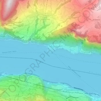
Name: Betlis topographic map, elevation, terrain.
Location: Betlis, Amden, Wahlkreis See-Gaster, Sankt Gallen, 8873, Schweiz (47.11521 9.12647 47.15521 9.16647)
Average elevation: 716 m
Minimum elevation: 416 m
Maximum elevation: 1,401 m
Other topographic maps
Click on a map to view its topography, its elevation and its terrain.
Schänis
Schweiz > Sankt Gallen > Wahlkreis See-Gaster
Schänis, Wahlkreis See-Gaster, Sankt Gallen, Schweiz
Average elevation: 725 m
Walde
Schweiz > Sankt Gallen > Wahlkreis See-Gaster > Eschenbach (SG) > Walde
Walde, Eschenbach (SG), Wahlkreis See-Gaster, Sankt Gallen, 8733, Schweiz
Average elevation: 896 m
Bollingen
Schweiz > Sankt Gallen > Wahlkreis See-Gaster > Rapperswil-Jona > Bollingen
Bollingen, Rapperswil-Jona, Wahlkreis See-Gaster, Sankt Gallen, 8715, Schweiz
Average elevation: 441 m