
Castleblayney Poor Law Union topographic map
Interactive map
Click on the map to display elevation.
About this map
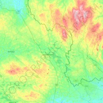
Name: Castleblayney Poor Law Union topographic map, elevation, terrain.
Location: Castleblayney Poor Law Union, County Monaghan, Ulster, Ireland (54.03578 -6.95392 54.22014 -6.49776)
Average elevation: 141 m
Minimum elevation: 33 m
Maximum elevation: 358 m
Other topographic maps
Click on a map to view its topography, its elevation and its terrain.