
Cellers topographic map
Interactive map
Click on the map to display elevation.
About this map
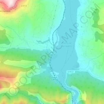
Name: Cellers topographic map, elevation, terrain.
Average elevation: 492 m
Minimum elevation: 349 m
Maximum elevation: 897 m
Other topographic maps
Click on a map to view its topography, its elevation and its terrain.
Senterada
Spanje > Catalonië > Pallars Jussà
Senterada, Pallars Jussà, Catalonië, 25514, Spanje
Average elevation: 1,143 m
Tremp
Spanje > Catalonië > Pallars Jussà
Tremp, Pallars Jussà, Lerida, Catalonië, 22583, Spanje
Average elevation: 908 m