Geolocate

Wichita topographic map

Click on the map to display elevation.

Wichita

The city lies on the Arkansas River near the western edge of the Flint Hills in the Wellington-McPherson Lowlands region of the Great Plains. The area's topography is characterized by the broad alluvial plain of the Arkansas River valley and the moderately rolling slopes that rise to the higher lands on either side.

Wikipedia (CC-BY-SA 3.0)

About this map

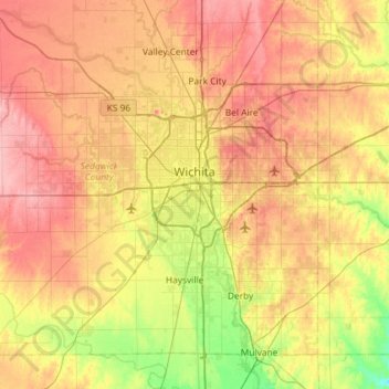
Name: Wichita topographic map, elevation, terrain.

Location: Wichita, Sedgwick County, Kansas, United States (37.48902 -97.73435 37.84020 -97.15300)

Average elevation: 408 m

Minimum elevation: 355 m

Maximum elevation: 459 m

Other topographic maps

Click on a map to view its topography, its elevation and its terrain.

Murray Gill

United States > Kansas > Sedgwick County

Average elevation: 395 m

Furley

United States > Kansas > Sedgwick County

Average elevation: 426 m

Sand Burr Hill

United States > Kansas > Sedgwick County > Wichita

Average elevation: 385 m

Wichita

United States > Kansas > Sedgwick County > Wichita

Average elevation: 410 m

Gear up for your next adventure:

🔥Emergency Fire Starters - Reliable ignition tools for survival situations in damp conditions
Altimeter Watches - Watches measuring altitude for mountain activities
🧴Sport Sunscreen Sticks - High-protection sunblock that won't run into your eyes on the trail
🦯Walking Poles - Supportive poles for long-distance walking
❄️Walking Crampons - Added traction for icy slopes and winter peak bagging

As an Amazon Associate, this site earns from qualifying purchases at no extra cost to you.